Northern Door County
Availability: Contact us for booking information
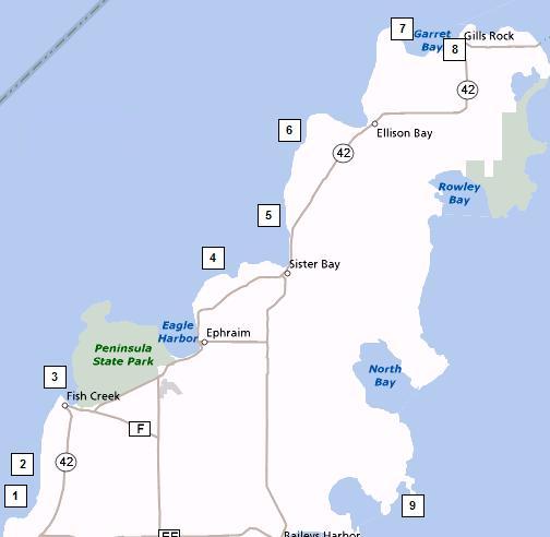
 1. Juddville Road Take Hwy 12 north of Egg Harbor 2-3 miles to Juddville Road. Go west 1/2 mile to dead end at water. This is an interesting dive with old pier structure. You can find 25' depth without going out too far. Bottom is rock in close, to sand out a little deeper. Protection from east wind.
2. Peninsula Player Road Half mile north of Juddville Road is Peninsula Player Road. Follow it down to the parking area on the north side. This area also has old pier structures with some depth. There has been china found here. It is also protected from the east. This area is a little deeper than the Juddville site.
3. Peninsula State Park A park sticker or daily pass will be needed here. After passing by park office watch for Weborg Pier. This will be in the Weborg camping area. Dive on either side of the concrete pier. Enjoy good visibility and chances are you will come up with a few fishing lures. There is a shelter building here with restrooms. Continue along the shore road and you will find other vehicle turn outs and small parking lots for scenic overlooks. These areas provide easy access to the water, and are nice shore dives.
4. Pebble Beach Continue north on 2 from Peninsula State Park to Pebble Beach Road, which is at the bottom of the hill. Follow Pebble Beach Road down to the water. This area is protected from all directions except from the north. Enter water at the dead end and go either east or west. This is a good area to pick up boat anchors and explore the ruins of an old pier which would be west of entry point. 25-35' max depth.
5. Waters End Road Continue north on Hwy 42 to Waters End Road just north of Sister Bay. Turn left to the dead end at water. There was a huge pier here at one time and there are huge pilings scattered around. This area has generally good visibility and fair amount of marine life. Swim out about 20 yards after the rocky bottom meets the sand to find the timbers. Protection here is from the east. Pilings at 25-30' depth.
6. Porcupine Bay Road Continue north on Hwy 42 to Porcupine Bay Road. Follow this down to water. Have a vehicle with good brakes. This is a hilly area with steep slopes. This area has a stony beach with some interesting rock structure below the surface with good visibility. Protection here is from the east. Depth of 70' can be reached from shore.
7. Fleetwing Take 42 north to Ellison Bay. Garrett Bay Road will veer off to the left. Follow this road to the old boat launch. The wreck of the Fleetwing will be east of the old boat launch about 100' off. Just enter at the boat launch. Go east in 10' of water. There are some old cribbing in the area. There are 4 sections of wreck in close and north of the wreckage about 20-25' depth another large section can be found. The Fleetwing was 136' long. It was a 3-masted schooner. It ran aground in Garrett Bay on Sept. 26, 1888. Usually good visibility can be found here.
8. Gill’s Rock Take Hwy 42 north of Ellison Bay to Gills Rock where Hwy 42 makes a 90 degree turn to the right towards Northport and the car ferry. Go straight to get to the parking lot of the Shoreline Resort. There is a nice shore dive in front of the resort where depths of 70' can be found not far off shore. Stay clear of the passenger ferry that operates nearby.


